Commentary

Ford Links Waze To Car Screens For Directions

While autonomous or self-driving cars get plenty of attention, it’s the increasing connectedness of cars that consumers will experience first.

New cars can come with sensors that detect when the car crosses a line drifting into another lane, sensors that cause the car to brake if a person or object unexpectedly crosses its path, or in-car connectivity allowing hands-free phone calls through the car’s sound system.

One of the most useful features of a connected car is the ability to get directions, whether through an in-car navigation system or turn-by-turn directions via Google Maps connected to the car’s sound system via Bluetooth.

The problem with phone-based directions is that despite the voice directions, to see the map of where someone is heading requires looking at a relatively small phone screen while driving.

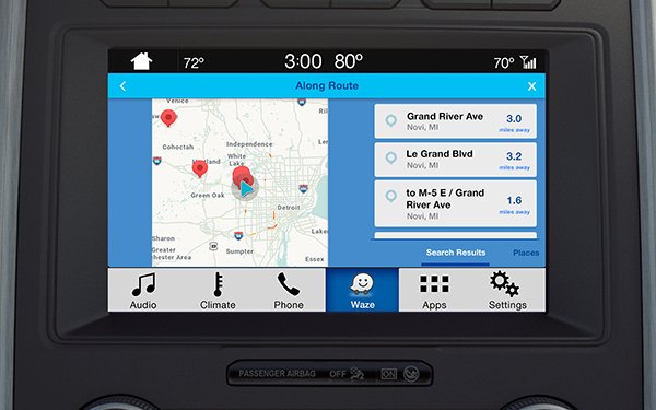
Ford is now tackling that issue head-on. The automaker just announced a partnership with Waze, the crowdsourced mapping company.

Once connected to Ford Sync AppLink, an iPhone with the Waze app can project its mapping onto the vehicle’s touchscreen with the driver able to find efficient traffic routes, cheaper fuel prices and report and see traffic accident locations.

The app can be controlled by voice and voice direction that come through the sound system in Sync 3-equipped Fords.

One slight irony is that the Waze-Ford deal works only on Apple devices, and Waze has been owned by Google since back in 2013.

This is just an indicator of what is coming in connected cars. Features from smartphones, still the most connected device of all, will be more tightly integrated with the increasing number and size of screens in cars.

The connected car ultimately will be as connected as the smartphone, creating a new meaning of mobile computing.

2 comments about "Ford Links Waze To Car Screens For Directions".
Check to receive email when comments are posted.
  1. R MARK REASBECK from www.USAonly.US , May 21, 2018 at 5:23 p.m.

    "Ford is now tackling that issue head-on."

    Nice play on words.
    So what hapopens, when they are repaving a road and the lines are not down yet?
    Or they are faded, or maybe road work destroyed them.
    How does the WAZE, have the MEANS to distinguish a line from a passing line?
    (like that one Chuck?)
    And what the car ahead of you all of sudden dodges a mattress in the road, just in time for your car's sensors to pick it up?  Slam on the brakes?  Swerve into another lane?
    I see this creating more  accidents than ever.

    And ARE they  going to rely on GPS techonolgy?
    Just Friday i was trying to find a road.  I was literally  a block west of a road that could have taken me there.  instead , it took me west in an 11 mile circle to get back
    to where I was wanted to go.   I was actually  about 3 miles form the actual address, but beAcuse I was past  the road , well I already explained.  And these people want millions of bits of info transmitting  with GPS?     INSANITY

  2. Chuck Martin from Chuck Martin replied, May 21, 2018 at 6:47 p.m.

    Waze and car-sensing technologies to ID lines in the road are different, just to clafiry Mark. Waze provides directions to the car screen, sourced by maps as well as people identifying trouble spots. The road sensors in a car typically show the lines in the dashboard when they can be seen, and the lane drifting feature does not work if the car cannot sense or "see" the lines. The car ahead dodging something is a totallly different issue, and potentially a very significant one, if a driver is not paying attention, whether lane assist is on or not.

Next story loading loading..